✘ Holyhead, Wales • August 28, 2025
⌖ Fortresses, Mountains, and Long Names in North Wales
Tour Route: Holyhead → Menai Strait Bridges → Caernarfon → Snowdonia (Llanberis Pass & Ogwen Valley) → Llanfair PG → Holyhead
Our excursion began in Holyhead, the largest town on Holy Island and a port that has connected Wales with Ireland since Roman times. Today ferries still cross daily to Dublin, continuing a tradition that made Holyhead one of the most strategic harbors in Britain. This was a tender port due to shallow waters. Once on the pier, we boarded a full motorcoach of 45 passengers and set out across the Isle of Anglesey, bound for the mainland.
The route eastward revealed Anglesey’s pastoral character: stone-built farmhouses, hedgerow-lined fields, and road signs posted in both Welsh and English. Our guide explained how the island, designated an Area of Outstanding Natural Beauty, is known as the “breadbasket of Wales” for its fertile land and long history of farming. Along the way she threaded in stories that gave shape to the passing landscape—how slate from these mountains once roofed cities across the world, how royal titles tied English kings to Welsh castles, and how shipwrecks on these coasts appeared in both history and literature.
① Photo Stop at the Menai Strait Bridges
⚲ Menai Suspension Bridge & Britannia Bridge
⧗ 10 minutes
The first stop came at the Menai Strait, the narrow tidal channel that separates Anglesey from mainland Wales. We disembarked briefly at a viewing point shared by several touring coaches, where both of the great bridges can be seen in sequence across the water.
To the east stood the Menai Suspension Bridge, designed by Thomas Telford and completed in 1826. It was the first suspension bridge in the world built to carry heavy road traffic and transformed the hazardous ferry crossing into a dependable link. By joining the newly built A5 road from London to Holyhead, it made Ireland more directly accessible for both passengers and the Royal Mail.
Beside it rose the Britannia Bridge, opened in 1850 under engineer Robert Stephenson. Originally built as a tubular railway bridge supported on massive limestone towers, it was partially destroyed by fire in 1970 and later rebuilt to carry both rail and road traffic. Together, the two bridges remain vital connections between Anglesey and the mainland.
Looking down, we could make out the stone outline of a medieval fish trap, revealed by the tide—an older reminder of how people have long depended on, and struggled with, these waters. With the fish trap below and the bridges above, the scene captured centuries of human effort to turn the Menai Strait from a dangerous barrier into a dependable thoroughfare.
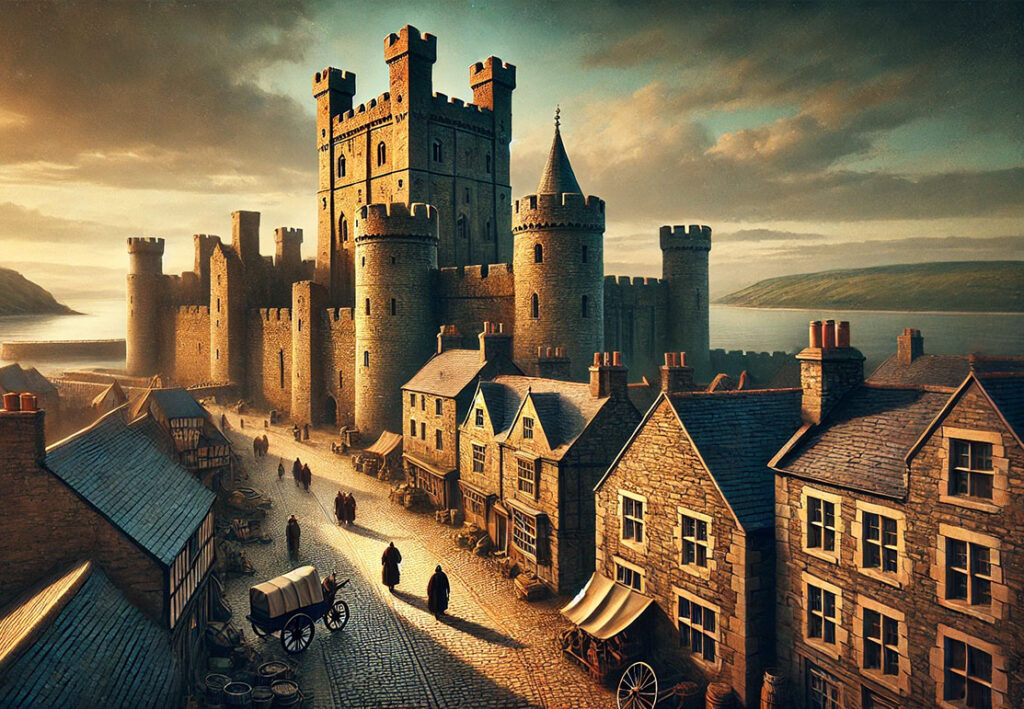
② Caernarfon Castle & Village Exploration
⚲ Caernarfon Castle, Castle Ditch, Caernarfon LL55 2AY, Wales
⧗ 2 hours
Crossing the Menai Strait, our coach entered the walled town of Caernarfon, dominated by its massive 13th-century castle. Built by Edward I as part of his “iron ring” of strongholds, the fortress was designed under the direction of James of St. George, its alternating bands of stone and polygonal towers projecting both strength and royal authority.
Inside the walls, our guide explained how the north side, once breached during a Welsh uprising, was rebuilt with angled arrow slits to give the illusion of a much larger garrison than the forty soldiers normally stationed here. At the Eagle Tower, the castle’s most powerful stronghold, we climbed spiral stairways for views over the Menai Strait and the medieval town. Exhibits within the grounds traced the castle’s role in English administration and its symbolism as a ceremonial stage for the Crown.
When the narrated portion ended, we were left to explore on our own. The experience was fascinating but often disorienting—the castle’s narrow staircases, twisting passages, and sudden dead ends made it easy to lose track of where we were. On a rainy day, the slick stone steps added to the challenge. We noticed individual visitors at the main ticket office received a single-page map of the layout, but when we asked about obtaining one, we were told firmly that maps were “not included” with group tours. The absence of even this simple guide made our self-directed exploration more difficult.
Afterward, we walked through Caernarfon’s stone-paved streets, lined with shops and cafés displaying bilingual Welsh and English signage. In the central square, we paused at the bronze statue of David Lloyd George, the only Welsh-born Prime Minister of Britain, whose leadership in the early 20th century remains a defining part of Welsh political history.
③ Traditional Welsh Lunch at the Black Boy Inn
⚲ Black Boy Inn, Caernarfon
⧗ 1 hour 30 minutes
After leaving the castle, our group walked a short distance through Caernarfon’s narrow streets to the Black Boy Inn, one of the town’s oldest taverns, dating back to the early 16th century. The inn has a long history as a gathering place for sailors and traders, reflecting Caernarfon’s maritime importance. Its name has been explained in several ways: some say it refers to the charcoal burners who once worked in the hills above the town, while another account links it to King Charles II, nicknamed “the Black Boy” for his dark hair and complexion.
Inside, the atmosphere was warm and traditional, with low timbered ceilings, stone walls, and heavy beams that gave the sense of stepping back in time. Lunch began with a plated serving of Welsh rarebit, a toasted bread dish topped with a savory cheese sauce, here accompanied by greens and a drizzle of sauce. The main course was a generous portion of Cottage Pie—minced meat baked under a layer of mashed potatoes—served with chips and garden peas on the side.
The stop offered not only a welcome rest but also a chance to experience regional cooking rooted in simple, locally sourced ingredients—lamb, leeks, and dairy products—that have shaped Welsh cuisine for centuries.
④ Scenic Drive through Snowdonia & Llanberis Pass
⚲ Llanberis Pass, Snowdonia National Park
⧗ Scenic Transit
From Caernarfon, our route turned inland and climbed steadily into the mountains of Snowdonia National Park, established in 1951 as the first and largest national park in Wales. The scenery shifted quickly: villages gave way to rows of pebble-dashed houses, a 1920s method of coating walls with lime, pebbles, and sand to weatherproof homes built in the postwar years. Beyond them, the land narrowed into stone-walled pastures where sheep grazed beneath peaks shaped by far older forces.
Our guide explained that these mountains are among the oldest in Europe, dating back more than 500 million years to the Precambrian era. Once taller than today’s Himalayas, they were carved by successive glaciations into the U-shaped valleys, corries, and hanging cliffs visible from the road. The remains of the Dinorwig slate quarry, once the largest in the world, still scar the slopes. Inside the abandoned workings lies Electric Mountain, a pumped-storage hydroelectric plant built within the old quarry chambers—an example of how the landscape continues to be harnessed for energy.
The coach climbed through the narrow Llanberis Pass, pressed between the Snowdon Massif on one side and the Glyderau range on the other. At its head stood the station of the Snowdon Mountain Railway, operating since 1896 with Victorian carriages that carry passengers toward the 3,560-foot (1,085 m) summit of Snowdon (Yr Wyddfa), the highest mountain in Wales and England. Although the peak was secluded in clouds, our guide described the seven main ascent routes, including the knife-edge ridge of Crib Goch, and noted how climbers such as Sir Edmund Hillary trained here before their 1953 Everest expedition.
Descending into the Ogwen Valley, the skyline was dominated by Tryfan, one of the few Welsh mountains that requires hands-and-feet scrambling to reach the top. Its summit rocks, known as Adam and Eve, are just over a meter apart; tradition holds that climbers leap between them to prove their courage. Even in mist and drizzle, Tryfan’s jagged outline confirmed why this area is considered one of Britain’s most dramatic mountain landscapes.
Continuing east, the road led into Bethesda, often called a “slate town.” Rows of 19th-century cottages lined the roadside, built for quarrymen once employed at the vast Penrhyn Quarry, then the largest slate quarry in the world. Bethesda is also remembered for the three-year strike of 1900–1903, a landmark in Welsh labor history. Though industrial activity has declined, the town’s slate heritage remains unmistakable, framed by quarry scars and terraced stone housing. It struck us as a place worth bookmarking for a future return, with a character distinct from the tourist routes that only pass through.
⑤ Free Time in Llanfair PG
⚲ Llanfairpwllgwyngyll, Isle of Anglesey, Wales
⧗ 45 minutes
The final stop of the day was at Llanfairpwllgwyngyllgogerychwyrndrobwllllantysiliogogogoch, a name deliberately created in the mid-19th century as a publicity stunt. Local officials extended the original village name into a 58-letter phrase to draw attention to the railway station and encourage passengers to disembark. The tactic succeeded: today Llanfair PG holds the record for the longest place name in Europe, and its oversized sign has become one of Anglesey’s most photographed attractions.
Because the site was busy with visiting coaches, our bus parked in the overflow lot behind the main shop. From there we walked to the front, where the façade of the James Pringle Weavers building displays the full name in bold lettering, with its English translation just below. Most visitors posed here for their photographs, and we joined them before continuing to the nearby railway station. Stepping onto the platform, we captured the name again on the official station sign, a reminder that behind the novelty, this is still an active transport stop.
Inside the James Pringle Weavers shop, we browsed displays of Welsh-made goods, packaged foods, and souvenirs. The exhibits reinforced the story of how a marketing idea from the 1800s turned a quiet village into a permanent tourist draw—proof that the invented name continues to do exactly what it was designed to achieve.
Transit: Return Drive to Holyhead
⚲ Isle of Anglesey
⧗ 45 minutes
The return drive followed the A55 across Anglesey, with a final look at landmarks along the Menai Strait. On the mainland side, the Nelson Monument recalled the admiral’s warning about these dangerous waters, while the Marquess of Anglesey’s Column honored Henry Paget, the Waterloo commander who became the first to wear a prosthetic leg. Further inland, the towers of Penrhyn Castle, built on slate wealth, stood as reminders of both prosperity and industrial conflict in North Wales.
Crossing back onto Anglesey, we passed Bangor University’s eco-park, designed as a self-sufficient research center, while our guide shared stories of migration to Liverpool, the Royal Charter shipwreck of 1859 that brought Charles Dickens to Anglesey, and the celebration of St. Dwynwen’s Day each January—sometimes called the Welsh Valentine’s Day.
As Holyhead came back into view, familiar markers framed the close of our journey: St. Cybi’s Church, set within the walls of a Roman fort, and the vast Holyhead Breakwater, begun in 1845 and still the longest in the United Kingdom. These final sights offered a fitting end to a day that linked fortresses, mountains, and a village name known worldwide.
☑ Who Is This Tour Best For?
- Castle lovers — the Eagle Tower, curtain walls, and medieval passageways offer a hands-on glimpse of the past.
- History enthusiasts — Edward I’s fortress at Caernarfon and the story of princes, rebels, and royal investitures.
- Scenic travelers — Snowdonia’s Llanberis Pass, Ogwen Valley, and slate-town Bethesda showcase some of Wales’ most dramatic landscapes.
- Cultural explorers — bilingual towns, the 58-letter name of Llanfair PG, and Welsh food traditions highlight local identity.
- Photography enthusiasts — bridges over the Menai Strait, castle battlements, slate quarries, and record-breaking signs provide diverse subjects.
- Travelers seeking a full-day excursion — varied stops balance history, scenery, and culture with manageable walking demands.
⊞ Tour Summary
- Tour Name: Caernarfon Castle & Snowdonia Mountains
- Offered By: Princess Cruises
- Total Duration: 8 hours
- Main Stops: Menai Strait bridges (photo stop), Caernarfon Castle, Black Boy Inn (lunch), Snowdonia National Park (Llanberis Pass & Ogwen Valley), Llanfair PG
- Drive-By Highlights: Isle of Anglesey countryside, Dinorwig Slate Quarry, Tryfan peak, Bethesda “slate town”

▣ Activity Summary:
- Walking Distance: Approx. 4,000 steps total across the day (castle interior, town streets, and Llanfair PG).
- Terrain: Uneven and often wet stone stairs and battlements at Caernarfon Castle; narrow spiral staircases; cobbled and flagged streets in Caernarfon; paved town areas in Llanfair PG; coach-based viewing in Snowdonia with short level walks at photo stops.
- Accessibility: Moderate — castle exploration involves steep spiral stairs, slippery stone, and no handrails; group tours do not provide maps, which can make navigation challenging; town walks on cobbles and flagstones; Llanfair PG is flat and accessible.
- Meals Included: Yes — plated Welsh lunch at the Black Boy Inn (Welsh rarebit starter, cottage pie with sides, dessert not specified, beverages included).
Excursion Disclaimer: Descriptions of shore excursions on OceansAfoot reflect individual travel experiences and are not official representations of the cruise lines or tour providers mentioned. All information is based on personal participation, publicly available facts, or traveler observation.
© OceansAfoot