✘ Gibraltar, United Kingdom • December 23, 2025
⌖ Fortress Rock, Wartime Tunnels, and Strategic Viewpoints
Tour Route: Gibraltar Port → Europa Point (Trinity Lighthouse & King Fahd Mosque) → Upper Rock (Barbary macaques photo stop) → World War II Tunnels & Victory Walk → Jock’s Balcony → Return to port (optional town drop-off)
With the clocks set back an hour that morning, our late meeting time (11:30am, inside the cruise terminal) gave us a rare, unhurried start—breakfast first, then ashore with an all-aboard deadline of 5:30pm in mind. Our small-group van held roughly a dozen guests, which kept everything efficient: quick loading, easy narration, and no long delays at photo stops.
① Europa Point
⚲ Europa Point (southern end of Gibraltar)
⧗ 20 minutes
From the port, we drove south along Gibraltar’s narrow peninsula toward Europa Point—the southernmost tip of the territory and the place where Gibraltar’s strategic geography becomes immediately legible. The Europa Point Lighthouse, often referred to as the Trinity Lighthouse because it is operated by Trinity House, has stood here since 1841, marking the entrance to the Strait of Gibraltar for vessels moving between the Atlantic and the Mediterranean.
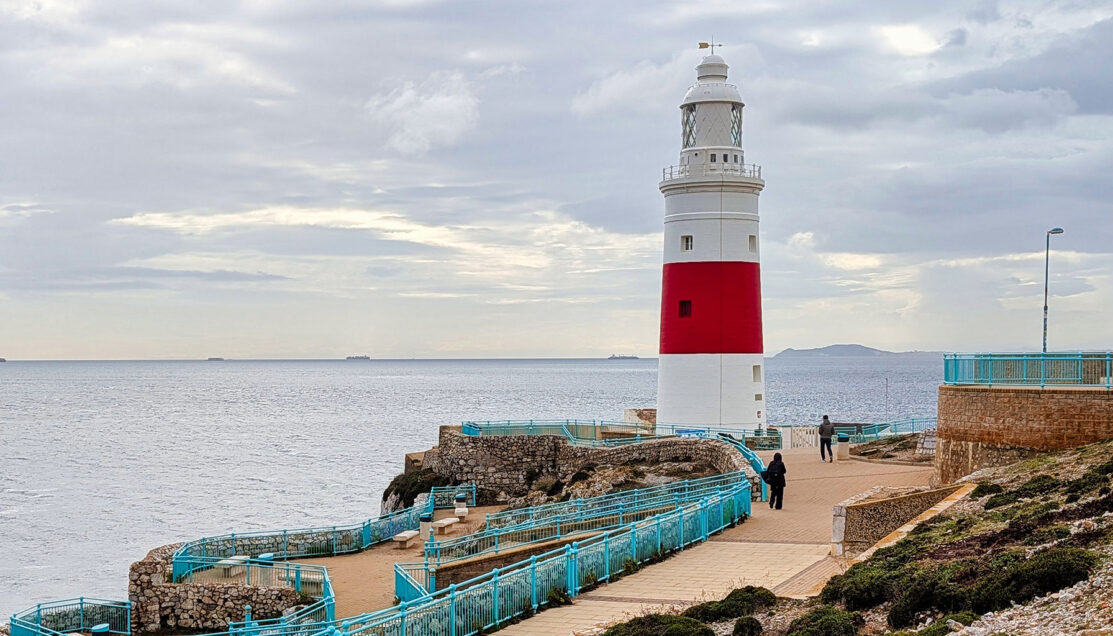
The lighthouse sits directly beneath the Rock itself, where water runoff from the Upper Rock spills through a visible drainage outlet cut into the limestone—an everyday reminder that Gibraltar is engineered as much as it is inhabited. Standing here, the sheer vertical face of the Rock dominates the view, emphasizing how little usable land exists beyond the road and fortifications.
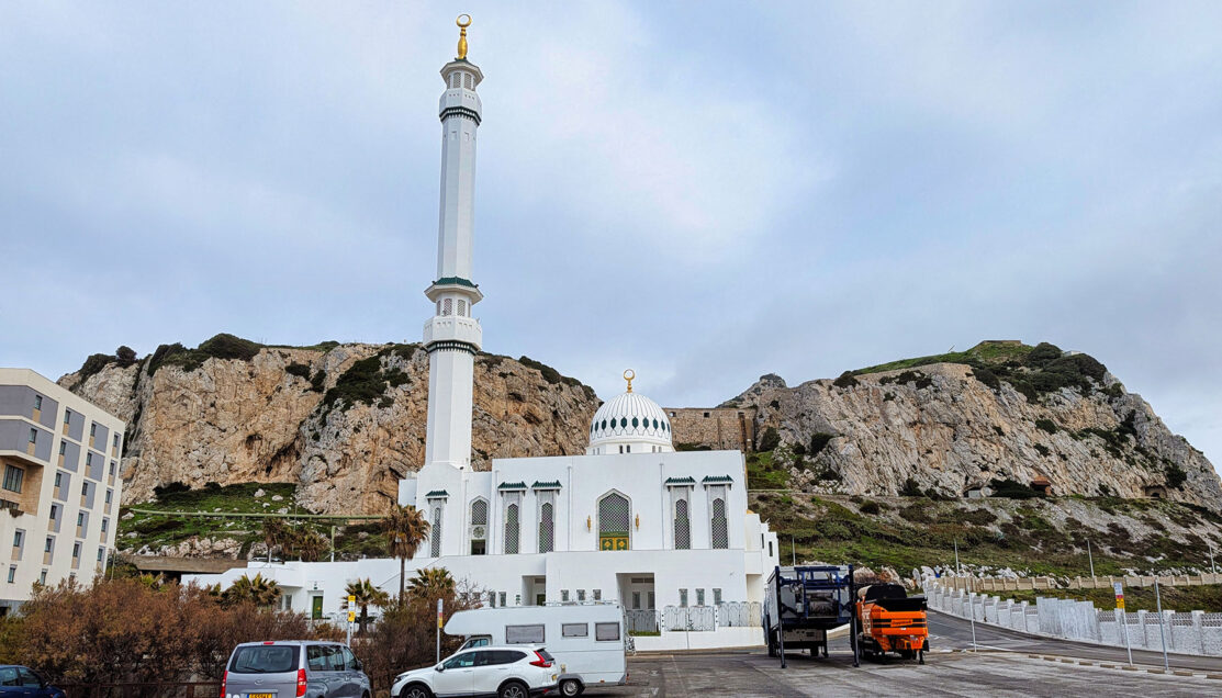
Across the road stands the Ibrahim-al-Ibrahim Mosque, more commonly known as the King Fahd Mosque, completed in 1997 after being gifted by Saudi Arabia. Its placement at Europa Point is intentional. Facing south across the Strait, the mosque visually reinforces Gibraltar’s position at the narrow boundary between continents.
This stop also functioned as the tour’s geographic orientation. From the railings near the lighthouse, the guide pointed out La Línea and mainland Spain to the north, while across the water the mountains of Morocco were faint but visible through the haze. At its narrowest, the Strait of Gibraltar measures roughly 14 kilometers (9 miles)—a distance that explains why, in clear conditions, Africa can appear strikingly close.
After a short window for photos—capturing the lighthouse, mosque, and exposed limestone of the Rock—we regrouped at the van and began the ascent toward the Upper Rock and the military infrastructure carved into it.
② Upper Rock Road: Barbary Macaques Photo Stop
⚲ Upper Rock Nature Reserve (roadside pull-off)
⧗ 5 minutes
As we continued upward toward the military tunnel complex, the driver mentioned a brief pause to look for Gibraltar’s Barbary macaques. In practice, this stop lies directly along the main Upper Rock route, making it less a diversion than an opportunistic pull-off when the animals are present.
We pulled in tight against the rock face and stepped out briefly, with little room to move beyond the narrow edge of the road. The macaques here are wild animals, not enclosed or staged, and whether a stop happens at all depends entirely on their movements. Before anyone approached, the guide gave clear, practical instructions: keep a respectful distance, secure hats and loose items, and watch body language closely. Lip-smacking or teeth-baring—behaviors the guide demonstrated—are warnings, not invitations.
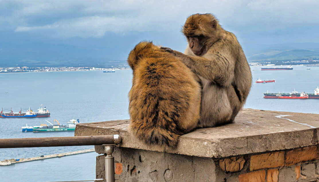
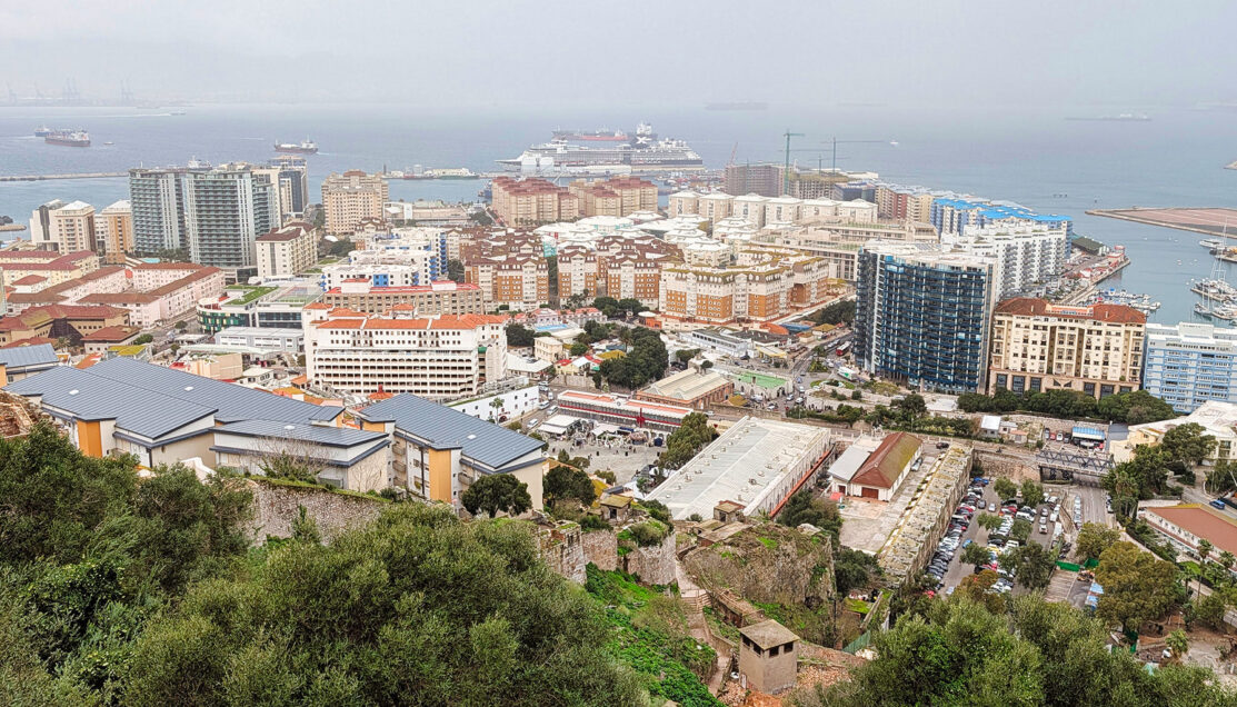
The setting mattered as much as the animals themselves. The macaques sat calmly along stone parapets and railings originally built for defense, now repurposed as informal observation points. Just beyond the low stone edge, the land drops sharply toward the harbor below, revealing marinas, apartment blocks, and the working port—views that underscored how completely the Upper Rock dominates the town. Much of the land now occupied by buildings is actually reclaimed from the sea, an ongoing effort to provide additional affordable housing for the citizens of Gibraltar and business opportunities to support the economy.
The guide also added historical context that’s easy to miss if the stop is treated as a novelty. These are Barbary macaques, a tailless species native to North Africa and the only wild monkeys in Europe. Their presence on Gibraltar likely dates back centuries, possibly introduced via merchant or military traffic. By the start of World War II, their numbers had fallen so low that Winston Churchill ordered reinforcements brought from Morocco, giving rise to the enduring local belief that as long as the monkeys remain, Gibraltar will remain British.
The stop was deliberately short—just enough time for photographs and observation without crowding the animals or disrupting the route. After roughly five minutes, we reboarded the van and continued upward toward the core of the excursion: the World War II tunnel system carved deep into the Rock.
③ World War II Tunnels
⚲ Upper Rock, Great Siege & WWII Tunnel System
⧗ 90 minutes
The van climbed higher into the Rock, and as we stepped out near the tunnel entrance, the weather turned decisively—rain began pouring just as we moved inside. What could have been an inconvenience instead became perfect timing. Within moments, we were underground, sheltered by the limestone mass that shaped Gibraltar’s wartime strategy.
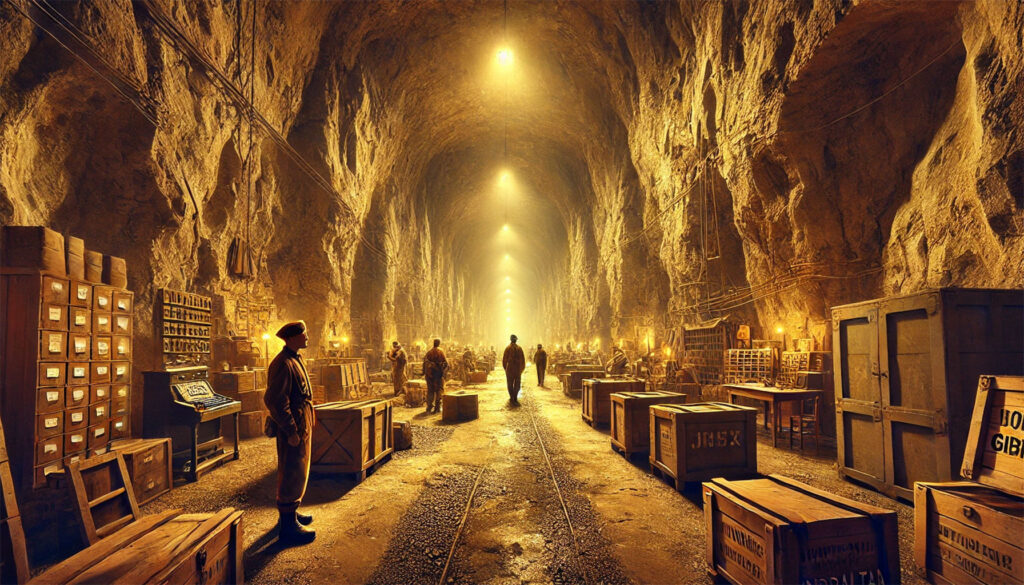
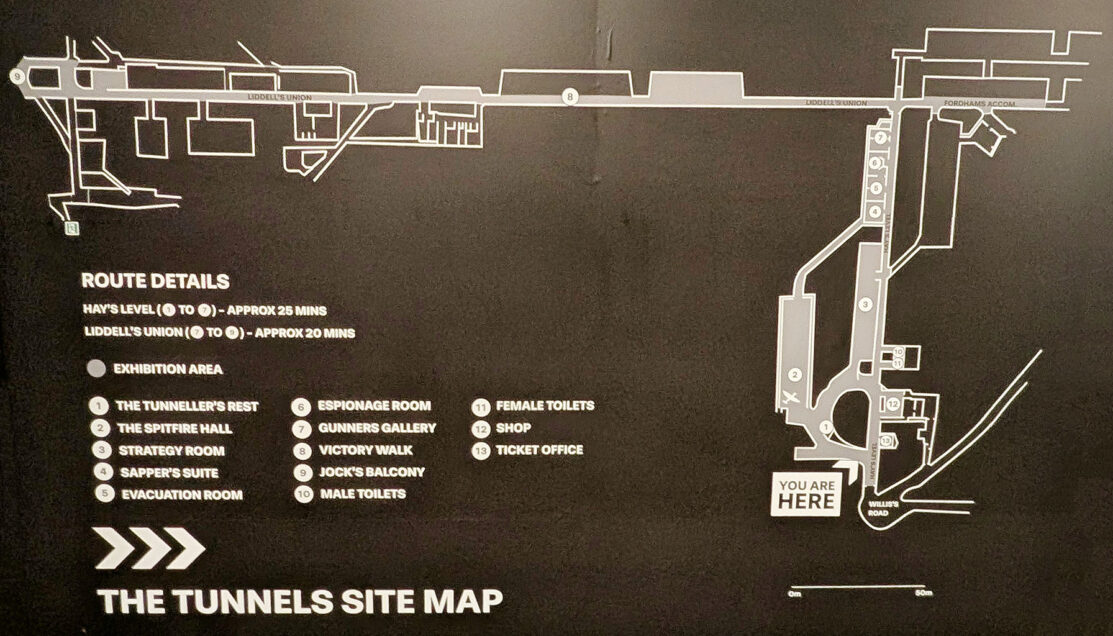
Entering the Tunnel Network
Gibraltar’s tunnel system spans over 50 kilometers (33 miles)—more tunnel length inside the Rock than road surface outside it. While excavation began during the Great Siege of the late 18th century, the most dramatic expansion occurred between 1939 and 1943, as Britain prepared for the possibility of German capture.
The objective was blunt and extreme: to make Gibraltar capable of sustaining a fully operational garrison entirely underground for months, or even years.
Before moving deeper, we were offered hard hats and given a brief safety overview. The main access chambers were deliberately wide, designed to accommodate vehicles, equipment, and large troop movements. Near entrances, shock-absorbing “blast pockets” were cut into the rock to dissipate bomb pressure before it could travel through the tunnel network.
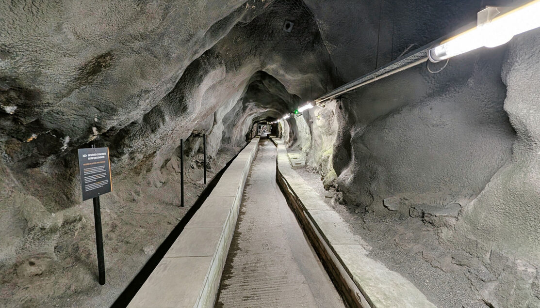
Life Inside the Rock
The route led through a sequence of exhibition galleries and original chambers illustrating how the Rock functioned as a self-contained fortress. These were not symbolic spaces—this infrastructure was designed for constant use.
Inside the Rock were:
- ➤ Hospitals and operating theaters, capable of performing surgery underground
- ➤ Power generation and mechanical workshops, including Royal Electrical and Mechanical Engineers’ depots
- ➤ Water reservoirs, fed by rainwater catchments carved into the limestone
- ➤ Kitchens, bakeries, and food storage areas
- ➤ Sleeping quarters for up to 18,000 troops, operating on rotating “hot bed” shifts
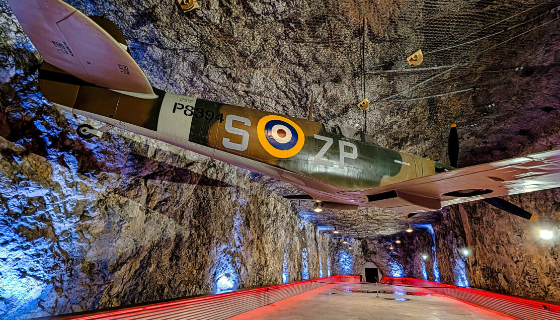
Photographs and artifacts documented aircraft assembly inside the tunnels—Spitfires shipped in crates, reassembled underground, and then rolled out for combat operations. One exhibit centered on a specific Spitfire named Gibraltar, underscoring how critical this location was to Allied air power in the Mediterranean.
Planning the War from Gibraltar
Several galleries focused on Gibraltar’s role at the highest levels of Allied command. Displays traced General Dwight D. Eisenhower’s presence in 1942, when Gibraltar served as a planning base for Operation Torch, the Allied invasion of North Africa. Other panels highlighted Winston Churchill’s direct oversight of the Rock’s defenses and its strategic role controlling access to the Mediterranean.
Equally compelling were the civilian stories. One section detailed the mass evacuation of Gibraltar’s population beginning in 1940. Within days, thousands were shipped out—first to Casablanca, then onward to Madeira, Jamaica, Northern Ireland, and the United Kingdom. Many families remained separated for more than a decade; some children returned to a Rock they barely remembered, or to parents they had never lived with.
Operation Tracer: The “Stay-Behind” Cave
One of the most striking exhibits addressed Operation Tracer, a top-secret contingency plan. If Gibraltar fell, a small team of officers would be sealed inside a hidden observation chamber within the Rock, tasked with spying on occupying forces and transmitting intelligence back to Britain.
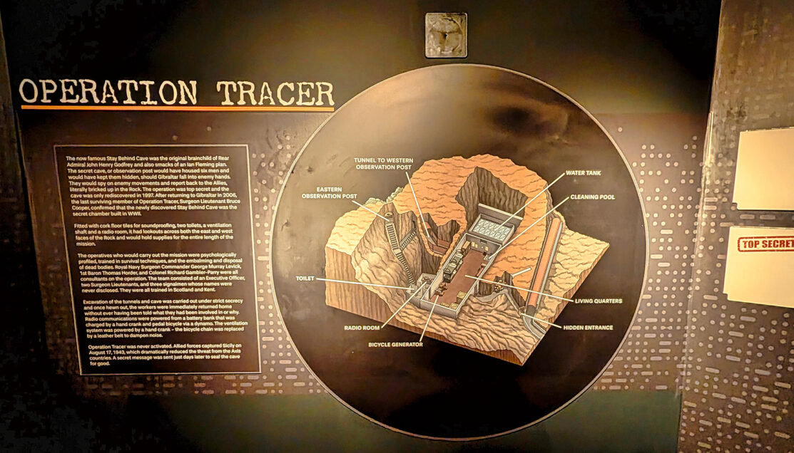
The secrecy was extreme. Builders were blindfolded and never told where they were working. Supplies were calculated for years of isolation. The plan was never activated, but the chamber was rediscovered decades later—confirming that the contingency had been real, detailed, and ready.
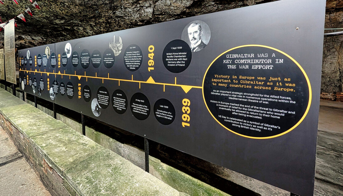
Victory Walk
The route continued along Victory Walk, a tunnel section dedicated to the war’s end. Timelines and photographs traced the shift from VE Day celebrations to the slow process of civilian return. Although the war ended in 1945, the final evacuees did not return until 1951, underscoring how long-lasting the disruption was for Gibraltar’s population.
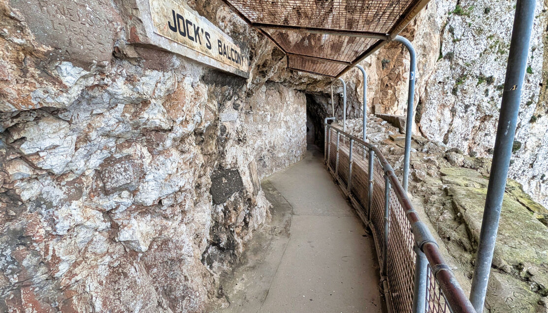
Jock’s Balcony
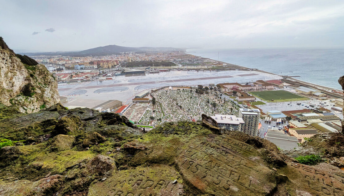
The visit culminated at Jock’s Balcony, one of the tunnel system’s most dramatic lookout points. Stepping out onto the exposed opening, we found ourselves suspended above the town, the runway, and the frontier with Spain.
From here, the geography that had driven everything we’d just seen snapped into focus: the narrow land connection to Spain, the sweep of the Bay of Gibraltar, and the shipping lanes threading through the Strait below. Even in rain, the view was expansive—but functional rather than scenic. This was not a place built for beauty, but for control, observation, and defense.
Exit and Return
After looping back through the tunnels, we returned to the van. Guests were offered the option of a town drop-off, but with steady rain still falling, everyone opted to stay aboard for the ride back to the ship—dry, warm, and with a far clearer understanding of why Gibraltar had been carved open from the inside out.
☑ Who Is This Tour Best For?
- Military & WWII history enthusiasts – extensive access to Gibraltar’s tunnel network, command planning galleries, Operation Tracer, and Victory Walk.
- Strategic-geography thinkers – clear understanding of why Gibraltar mattered, reinforced by tunnel design, lookout points, and views over the Strait and land frontier.
- Engineering & infrastructure fans – blast pockets, underground utilities, aircraft assembly areas, and logistics scaled for a hidden garrison.
- Wildlife-with-context travelers – brief, respectful encounter with wild Barbary macaques in their natural Upper Rock setting.
- Scenery seekers & photographers – elevated views over the harbor, runway, and Bay of Gibraltar, especially from Jock’s Balcony and Upper Rock road stops.
- Cruisers who prefer substance over shopping – tightly structured route with minimal downtime and strong narrative continuity.
⊞ Tour Summary
- Tour Name: The Military Heritage of Gibraltar (Small Group)
- Offered By: Celebrity Cruises
- Total Duration: 4–5 hours (varies by itinerary and weather)
- Main Stops: Upper Rock Road (Barbary macaques photo stop), World War II Tunnel System (exhibition galleries, Victory Walk, Operation Tracer exhibit), Jock’s Balcony viewpoint
- Drive-By Highlights: Upper Rock Nature Reserve, military batteries and fortifications, Gibraltar town and harbor, runway and frontier with Spain, Bay of Gibraltar and Strait shipping lanes
▣ Activity Summary
- Walking Distance: 1.5–2 miles total (mostly underground and paved surfaces)
- Terrain: Paved tunnels and galleries; occasional ramps and stairs; exposed viewpoints with narrow edges; uneven rock surfaces in places
- Accessibility: Moderate – tunnels are wide and well-lit but include slopes and some stairs; not fully wheelchair accessible; suitable for most mobile travelers
- Meal Included: No
Related Mediterranean Travel: Explore more Mediterranean cruise ports and shore excursions in our complete regional guide.
→ Mediterranean Cruises & Shore Excursions Guide
© OceansAfoot